Camp Mystic Evacuation Timeline ~ Guadalupe River Flash Flood (July 4, 2025)
Why 30 Minutes Matters ~ Testing the Official Accounts Against the USGS Hunt Gauge
When reporters began reconstructing the events at Camp Mystic on the night of July 4, 2025, the story turned on a timeline.
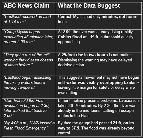
Family spokesperson Jeff Carr told The Washington Post that longtime director Dick Eastland began moving girls to higher ground around 2:30 a.m. ~
Speaking to ABC News, Carr revised that account, suggesting evacuations began closer to 2:00 a.m. Just forty-five minutes after the National Weather Service issued a “life-threatening flash flooding” alert to phones.
Both of Carr’s timelines ~ 2:30 and revised 2:00 a.m. ~ were published on July 14, 2025, in The Washington Post and ABC News, respectively.
On the surface, the difference may seem trivial.
In the context of a flash flood, it is not.
Thirty minutes can be the difference between movement and chaos ~ life and death.
Neither version explains the outcome ~ twenty-seven children and counselors lost their lives.
If the evacuation began at 2:00, why did so many perish in the flood?
Camp Mystic on the Guadalupe River ~ Location, Elevation, Floodplain (Kerr County, Texas)
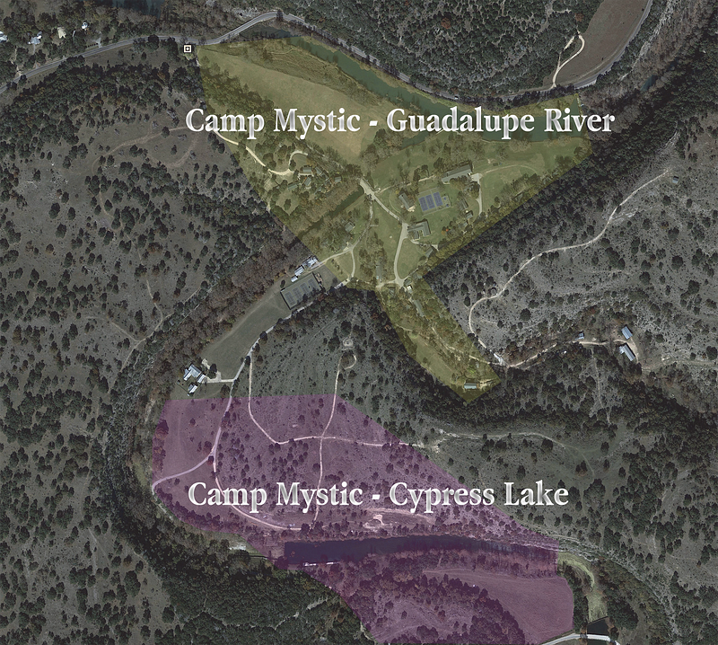
Camp Mystic sits along a bend of the South Fork of the Guadalupe River in Hunt, Texas.
Its layout is deceptively idyllic: activity fields, cabins, and docks run parallel to the water, while the chapel and dining hall sit further uphill.
Many of the oldest cabins stand just a few hundred feet from the riverbank, on ground barely higher than the water ~ some within the mapped floodway.
Camp Layout and Elevation ~ Flats vs High Ground at Camp Mystic
Imagine walking through the camp with Camp Mystic’s brochure in hand.
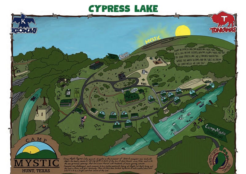
At the crest sits Cypress Lake, a reservoir that marks the highest ground. Around it are the stables, the archery range, and newer cabins built above the floodplain.
Descend the slope and you pass fields, a recreation hall, and older bunkhouses.
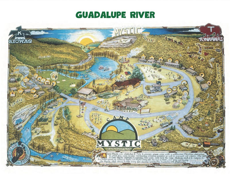
Continue downhill and you reach the Flats ~ a strip of cabins sit just about level with the river (far right on your map).
Finally, at the bottom, the Guadalupe River bends through the limestone ~ summertime incarnate.
This terrain makes Mystic beautiful ~ and vulnerable.
When the river overtops its banks, water doesn’t just rise vertically ~ it spreads sideways across the Flats, cutting off escape routes uphill and sweeping debris laterally.
Take a look at this FEMA flood map of the camp.
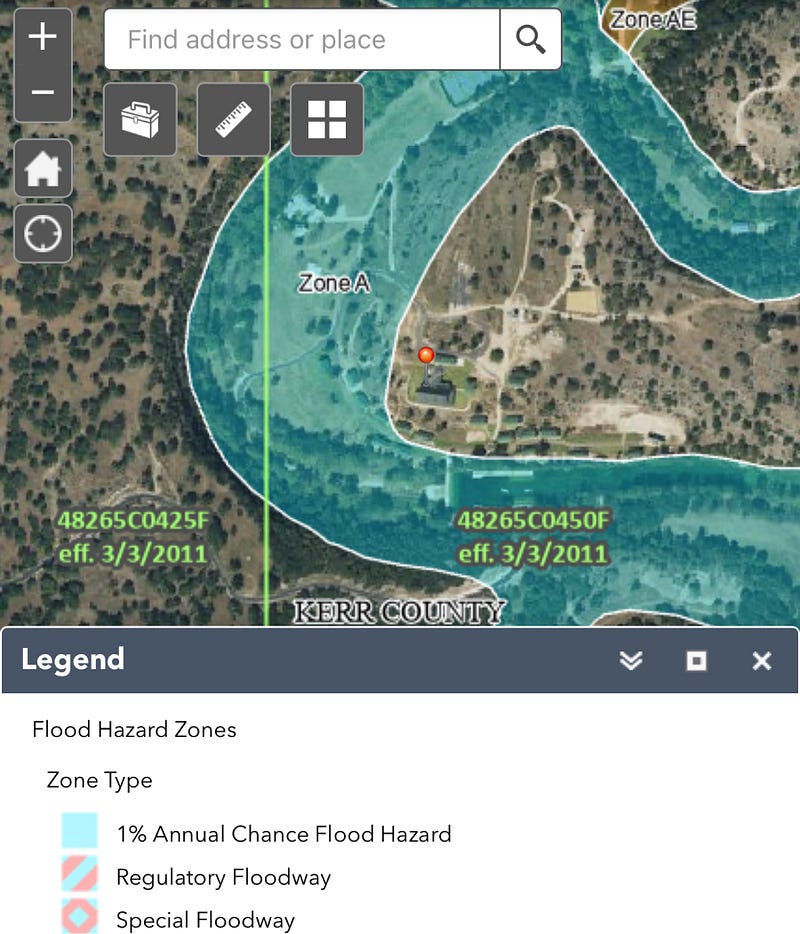
A 1% annual chance of flooding stacks up to ~ 26% over 30 years, one out of four.
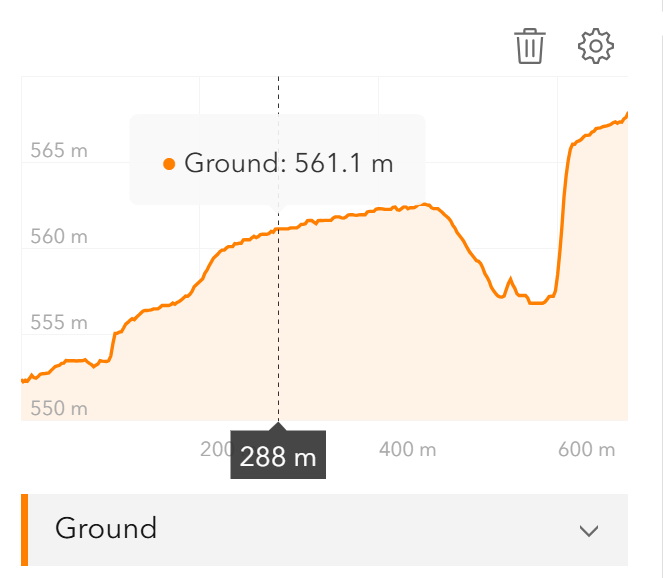
Here’s an elevation map from the USGS ~
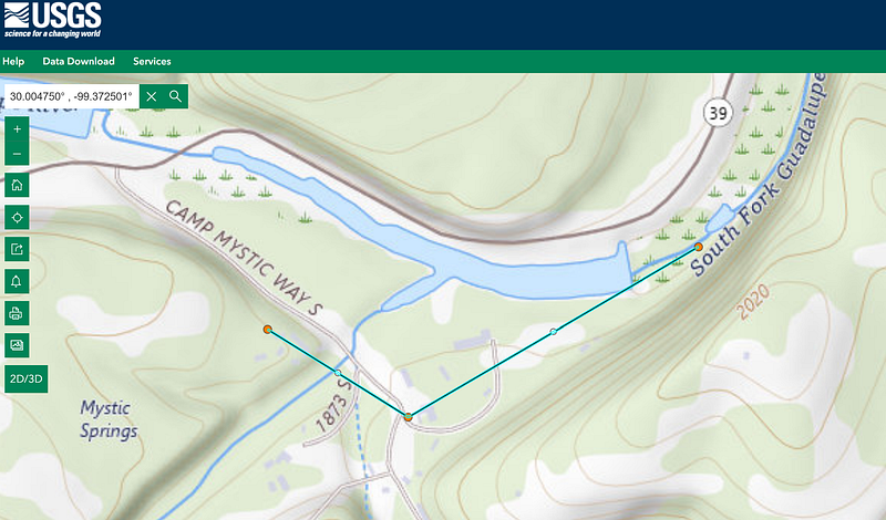
In the Hill Country’s steep watersheds, a few inches of rainfall upstream can raise the river ten feet or more in under an hour.
Watch flood footage from the Llano River during the July 4, 2025 floods.
This is Llano River in the same region during the floods on July 4th, 2025.
Each jump up the river gauge represents entire sections of the camp underwater.
Flash-Flood Evacuation Math ~ Mobilization, Distance, Bottlenecks, Headcount
Emergency modelers approach this question with a handful of inputs:
Population size, mobilization lag, movement speed, distance to safety, and chokepoints along the way.
For a camp like Mystic ~ roughly 400-500 campers plus staff ~ the parameters fall into a sobering range.
Mobilization: waking people, calming them, organizing groups, assigning leaders: 20-40 minutes.
Walking speed at night with children on wet ground: 1-2 feet per second (0.7-1.3 mph). In rain and darkness, planners use 1 ft/sec as the realistic value.
Distance from the lowest cabins to higher ground: 300-700 feet uphill, depending on location.
Operational reality: counselors must move groups in waves, stop for slips or crying, and often double back to guide stragglers.
A quick check tells the story:
At 1 ft/sec, covering 500 feet to safety takes 8-10 minutes once a group is moving. You can’t move 100 people in one wave. Groups of 10-20 campers with 2 staff imply multiple waves, spread over 30-50 minutes. Add mobilization lag, and the total clearance time stretches to 30-70 minutes.
Flats Cabins at Camp Mystic ~ Lowest Elevation, Highest Flood Risk
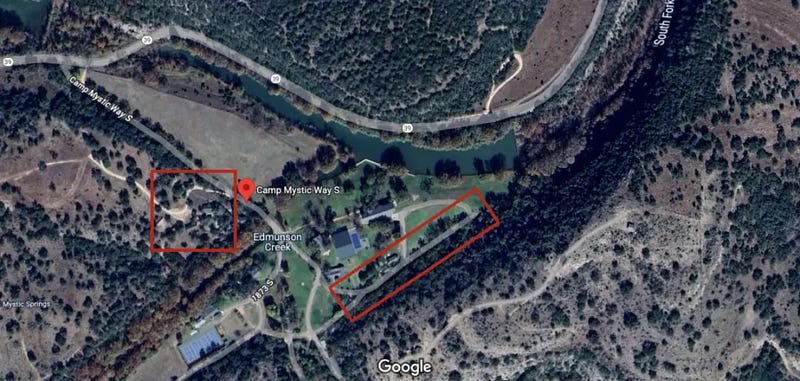
The red box on the right shows the location of the cabins in the flats.
Each cabin would have held 10-15 campers (a few hundred total in the flats). If counselors focused solely on those cabins, mobilization (20-40 minutes) plus movement uphill (8-10 minutes per group) estimates suggest it could take around 30-70 minutes just to clear the flats.
By then, the river gauge would already have been climbing through 15 feet ~ and water would have entered the cabins.
Why 30 Minutes Matters ~ Nighttime Evacuation vs a Rising Flash Flood

If everything goes right, you might get everyone to higher ground in 30 or 40 minutes.
If panic, weather, or debris slow things, the estimate drifts toward 70 minutes.
Any delay and you start pushing into dangerous territory.
A nighttime evacuation is not a switch to flip ~
It’s a fragile sequence of events.
Against a vertical flood curve, delays are the difference between guiding children uphill and carrying them through a rising current.
Wait to “assess the flooding”?
You miss the safe evacuation window.
USGS Hunt Gauge ~ Guadalupe River Rise 1:00-4:30 a.m. on July 4, 2025
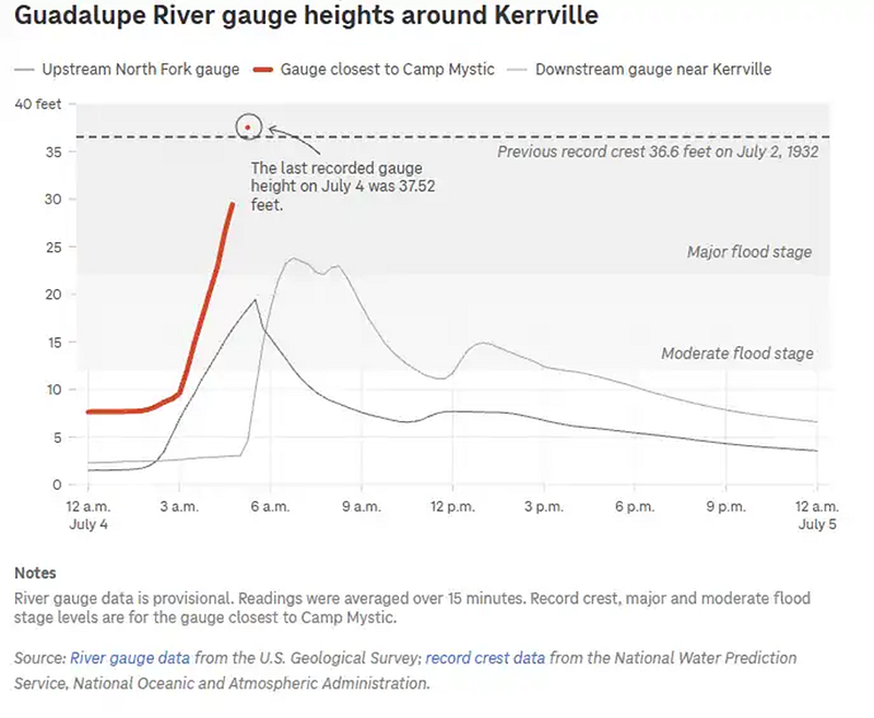
The first riverside cabins in the Flats begin to flood when the river reaches 15 feet.
Severe flooding across much of the property begins around 25 feet based on FEMA flood maps.
Anything above 32 feet and the camp is overwhelmed.
It helps to zoom in on the critical hours between 1:00 and 4:30 a.m. ~
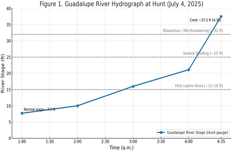
At 1:00 a.m., the Guadalupe stood at 7.7 feet.
By 4:35 a.m., it blasted up to 37.5 feet.
Against the evacuation estimates, the window shrinks quickly ~
If counselors began mobilizing at 2:00 a.m., they had perhaps an hour before the Flats were inundated.
If movement began closer to 2:30, the evacuation was already colliding with floodwater.
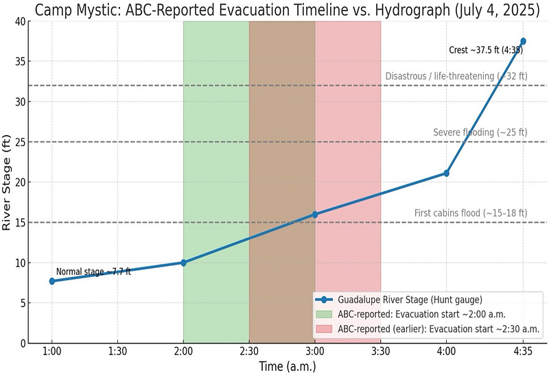
Reported Evacuation Timeline vs Hydrograph ~ Testing the Narrative
In the weeks after the flood, national news outlets scrambled to explain how twenty-seven children and counselors could die in a modern camp with phones, alerts, and vehicles on site.
ABC News published one of the most widely circulated accounts, quoting family spokesperson Jeff Carr. Carr said the camp received the first alert at 1:14 a.m. and began evacuating campers about 45 minutes later.
He added that such warnings were “run-of-the-mill,” the kind they had seen “dozens of times before.”
He also said staff spent time assessing the rising waters before acting.
On paper, that narrative sounds plausible.
Compared Against the Hunt Gauge, the Spokesperson Timeline Needs Testing
Flash-Flood Readiness for Camps and Schools ~ Practical Takeaways
Camp Mystic’s loss underscores a difficult truth:
The evacuation window is often shorter than the time it takes to mobilize.
Preparation cannot guarantee survival, but it can improve the odds.
That means:
- Knowing whether your camp, school, or neighborhood sits in a floodway.
- Understanding not just how high a river rises, but how fast.
- Practicing evacuation with the expectation that warnings may leave no grace period.
Open Questions After the Camp Mystic Flood ~ Timing, Preparedness, Coverage
After reviewing the hydrograph and the reported timeline, three unresolved questions remain:
1. When did evacuations actually begin at Camp Mystic?
Was movement underway before the first cabins flooded, or only after water was already inside?
2. How can organizations like Mystic prepare for rapid-onset disasters?
If it takes 30 ~ 70 minutes to move a sleeping population, what systems or drills can bridge that gap?
3. Should ABC have questioned the camp spokesman’s statements?
And if so, why didn’t they?
In the aftermath of tragedy, repeating untested narratives risks reshaping public memory at the expense of truth.
Mystic’s tragedy is not about a single night in Texas ~
It’s about the narrow margin of safety when waters rise faster than people can move.
More in the Camp Mystic Series ~ Flood Timeline, Risk, Accountability
This story is part of my ongoing Camp Mystic Series at The Balance Sheet, where I’m unpacking what happened along the Guadalupe River on July 4, 2025, and what it means for flood risk, safety, and accountability.
What Happened at Camp Mystic? ~ A narrative reconstruction of the disaster’s timeline and key decisions.
The Water’s Rising ~ A data-driven look at rainfall intensification and extreme weather in Texas Hill Country.
The Water’s Rising: What the Data Really Says About Extreme Weather
Flash Flood Alley ~ Why the Hill Country is one of the most dangerous flash flood zones in America.
Who’s Responsible for Building in the Floodplain? ~ How cabins get built and approved at the local level, and what the feds can do to disincentivize development in risky spots.