Flash Flood Alley: Why Flash Floods Kill
Texas Hill Country and the Limits of Early Warning
Why Flash Floods in the Texas Hill Country Are So Dangerous
The Texas Hill Country is beautiful, rugged ~
and deadly when it rains.
The Texas Hill Country is a region of limestone cliffs, narrow river valleys, and fast-draining slopes between San Antonio and Austin.
Tourists come for the picturesque rivers and limestone cliffs.
Locals know how fast those rivers rise.
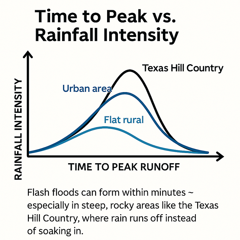
The region’s steep slopes and limestone bedrock make it one of the fastest-draining flood environments in the country.
Rain doesn’t soak in.
It runs off, racing downhill into dry creeks and narrow rivers.
That’s how a shallow stream can become a 20-foot wall of water in under an hour.
“Flash Flood Alley” is a nickname, not an official term, but hydrologists and emergency managers use it all the same.
The term refers to the I-35 corridor from San Antonio to Dallas, cutting straight through the Hill Country. Extreme rain events are common, and the terrain makes those events far more dangerous.
This region has history:
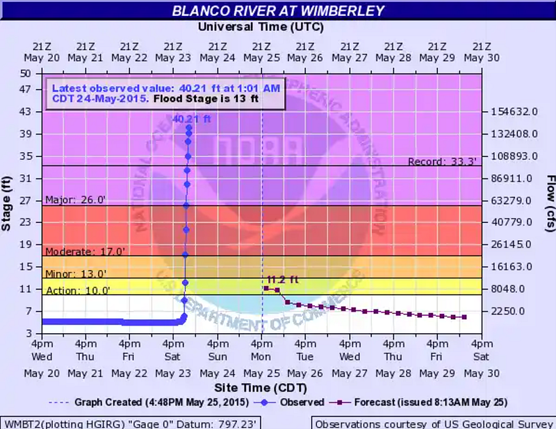
- Blanco River, 2015: Rose over 30 feet in 3 hours, killing 13 people in Wimberley and sweeping homes from their foundations.
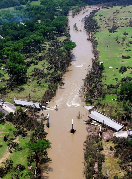
- Llano River, 2018: Crested at a record 39.9 feet, snapping the 85-year-old FM 2900 bridge in half.
- Guadalupe River, 1987: A church van was swept away in Hunt, killing 10 teenagers.
Past Hill Country floods show the pattern. The Blanco River rose from base flow to catastrophic levels in a few hours in 2015, and the damage pattern along the river showed how fast a channel can strip vegetation, damage homes, and overwhelm ordinary evacuation assumptions.
“People think flash floods just mean lots of water. In the Hill Country, the water runs you down.”
Series Note
This is the third entry in my ongoing series about the deadly July 4th flood at Camp Mystic.
This piece explores why flash floods are so dangerous, how our warning systems work (and fail), and what the tragedy at Camp Mystic tells us about preparedness in high-risk places like the Texas Hill Country.
I work as a life safety consequences specialist with the U.S. Army Corps of Engineers, where I analyze how floods and infrastructure failures put human lives at risk ~
and how we can do better.
If you missed the earlier essays, catch up here:
Disclaimer: The views expressed here are my own and do not represent the official policy or position of the U.S. Army Corps of Engineers, the Department of Defense, or the United States Government.
How Flash Floods Work ~ and Why They’re More Deadly Than You Think
Most people think of floods as slow ~ a creeping up, inching higher, day by day until the river is fit to burst.
They may picture a coastal flood, with hurricane driven storm surge pushed in by winds with plenty of advance notice and ample opportunity to evacuate.
Flash floods aren’t like that.
They arrive fast, often with less than an hour of warning, and they don’t need days of rain to cause damage.
A single thunderstorm stalling over the wrong ridge can fill a riverbed in minutes.
Water can rush down from upstream, even if your skies are clear.
That timing difference is the core danger. A river flood can give people hours or days to move. A flash flood can turn warning time into minutes.
Why Nighttime Flash Floods Are Especially Dangerous
People are asleep.
Visibility gone.
Water rising outside the door.
Evacuation becomes a race against the clock ~ and against the water.
How the Flash Flood Warning System Works (and Where It Breaks Down)
Theory and Practice
In theory, the National Weather Service (NWS) alert process follows a straightforward path from the NWS to the public.
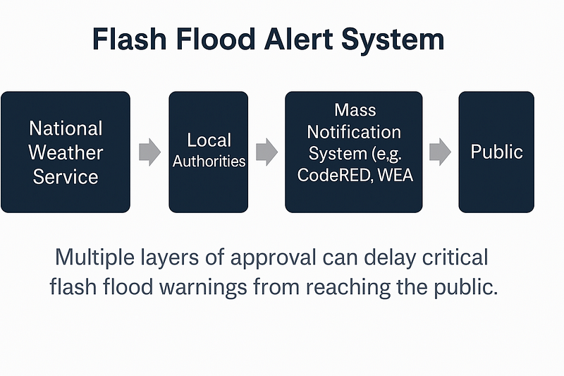
The flash flood alert system has multiple layers ~
and multiple failure points.
The NWS is responsible for monitoring rainfall, gauging risk, and issuing the first formal alerts.
These alerts follow a standard progression:
- Flash Flood Watch: Conditions are favorable for a flash flood
- Flash Flood Warning: A flash flood is imminent or occurring
- Flash Flood Emergency: A rare, highest-tier alert for catastrophic flooding and life-threatening conditions
Once these alerts are issued, local officials and automated systems have to move warnings into mass notification channels like CodeRED or Wireless Emergency Alerts (WEAs).
Delays cost lives when every minute counts.
Potential Failure Points
- Some systems require manual approval from county emergency managers
- Not all residents are enrolled in opt-in systems like CodeRED
- Cell coverage and power outages can delay or block delivery
- Lack of communication between the NWS and the local community
- Individuals with the authority to make an evacuation call may be asleep or otherwise incapacitated
Potential Solutions
Some problems can’t be solved overnight. But others can be addressed with better systems, faster protocols, and smarter communication.
Here’s where experts say progress is possible:
- Automate local alert triggers when NWS issues a Flash Flood Emergency
- Increase gauge density in rural areas prone to flash floods
- Require passive opt-in for CodeRED-style alerts during camp registration or school enrollment (You could even geofence areas and send alerts to everyone within the designated flood risk zone)
- Design elevation-based evacuation plans at camps and rehearse them like fire drills
- Invest in offline alert backups, such as sirens or radio, where cell service is unreliable
There’s no silver bullet.
But these changes would make the system faster, more reliable, and more likely to save lives ~ especially in the middle of the night.
Camp Mystic Flood Timeline: How the Alert System Failed
A flash flood watch was issued on July 3rd.
This should have signaled to everyone in the area that they should be on their toes ~ ready to act at a moment’s notice.
Overnight and leading into the morning of July 4th the official warning timeline looked something like this:
- 1:14 a.m.: First Flash Flood Warning issued by NWS
- 4:03 a.m.: Upgraded to Flash Flood Emergency
- 4:22 a.m.: A local firefighter requested CodeRED alert activation for Hunt, TX, according to later dispatch reporting
- ~4:45 a.m.: Camp Mystic evacuation efforts were underway, according to early public reporting
- 5:10 a.m.: The USGS Hunt gauge, downstream of Camp Mystic, crested at 37.52 feet, according to the Commerce Department OIG review
Camp Mystic lost power sometime between 4:30 and 5:00 a.m.
Wireless alerts did not reach everyone in the same way or at the same time. Later reporting and public records focused on the gap between NWS warnings, local alert activation, and what people near the river actually received.
There were no physical warning sirens near the camp.
(There were discussions about sirens years before the flood. More on that in the next essay.)
While Kerr County did eventually issue CodeRED alerts, it wasn’t fast enough.
A 15-minute delay can mean the difference between life and death.
Why Camp Mystic Couldn’t Evacuate in Time
It’s easy to say people should’ve evacuated.
But evacuating isn’t always simple ~
Especially in the dark, when people are asleep, and floodwater is rising outside your door.
Camp Mystic was built in a known flood zone.
FEMA maps show portions of the site inside Zone AE, with some structures near or inside the regulatory floodway.
These zones are known to flood during 1% annual chance events ~ and in this case, the flood was much worse.
Camp Mystic sits in a bowl-shaped bend of the Guadalupe River.
Flood Risk at Camp Mystic (FEMA FIRM Panel)
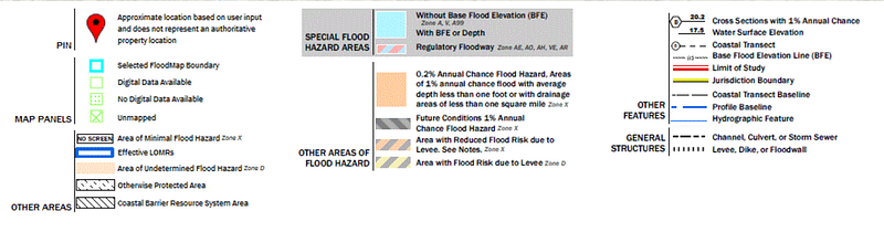
Several cabins and roads sit within Zone AE ~ a high-risk flood zone with a known base flood elevation. Zone AE indicates a 1-in-100 chance of flooding each year.
The site also borders a mapped regulatory floodway, the part of the floodplain where velocity and inundation risk carry the greatest planning consequences.
Roads in and out cross low areas.
Once the power failed, staff had to rely on flashlights, walkie-talkies, and muscle to get girls to higher ground.
It’s not that people didn’t try to evacuate…
The timeline and terrain made it
nearly impossible.
How Multiple System Failures Turned a Flash Flood Into a Tragedy
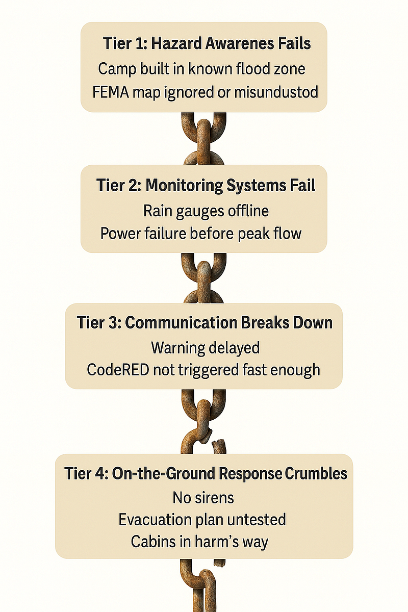
Flash floods test emergency response systems at every level.
On July 4th, the system failed:
- Alert systems were too slow
- Rain gauges weren’t functioning
- Emergency communications were fragmented
- Site planning placed kids in harm’s way
- The camp’s emergency planning did not appear to match the speed and scale of the flood (despite having an emergency plan reviewed shortly before the flood)
It wasn’t just one agency or one decision.
It was decades of assumptions
~ about weather, flood maps, warning time, and planning margins ~
catching up all at once.
Flash Flood Safety Lessons for Camps, Officials, and Hill Country Residents
The big takeaway?
The consequences of a flash flood are about more than just how much rain falls
It’s about how fast it hits, how the terrain moves it, and how prepared (and aware) the people are.
If you run a camp, park, or group facility in a flood-prone area:
- Know your flood zone. Make sure other people know.
- Plan for nighttime floods ~ including evacuation routes in total darkness.
- Rehearse flood evacuation drills like you would fire drills. Also push for better alerts, faster protocols, and backup plans that don’t require power or cell service.
Because next time, the warnings might come late ~
or not at all.
How Planning Decisions Put Camp Mystic in Harm’s Way
What’s Coming in the Next Piece
In the next article, I’ll zoom in on the site-level decisions that shaped this tragedy: how cabins ended up in a mapped floodway, a full analysis of the communication breakdown between NWS and Camp Mystic, and the responsibilities of (and relationship between) the federal and local governments.
This wasn’t the first deadly Hill Country flood.
And if nothing changes, it won’t be the last.
Because “in the hill country,
the water runs you down.”
Frequently Asked Questions About the July 4 Texas Flood and Flash Flood Alley
How many people died in the July 4 flood overall?
Early estimates put the statewide death toll at over 120 people. The worst single-site tragedy happened at Camp Mystic, where at least 27 girls and staff were killed when floodwaters surged through before dawn.
How many died at Camp Mystic?
At least 27 people, mostly campers, lost their lives. Many others were injured or had to be rescued. It was one of the deadliest U.S. flash floods in decades.
Where is Camp Mystic located?
Camp Mystic is a private Christian girls’ summer camp located on the Guadalupe River near Hunt, Texas ~ part of the Texas Hill Country, also known as “Flash Flood Alley.”
Is the Guadalupe River man-made?
No. The Guadalupe River is a natural river, though portions are dammed for flood control and water supply. It runs from Kerr County to the Gulf of Mexico and is a popular site for tubing, kayaking, and camping.
What is Flash Flood Alley?
“Flash Flood Alley” refers to the stretch of Central Texas between San Antonio and Dallas, especially the Hill Country. It’s not an official designation, but experts use the term to describe the region’s extreme flash flood risk. The combination of rocky terrain, steep slopes, and narrow river valleys creates the perfect conditions for sudden, dangerous floods.
Why do flash floods happen so fast in the Hill Country?
The ground here is made of limestone, which doesn’t absorb water. When heavy rain hits, it runs off fast ~ rushing into dry creeks and riverbeds. In the right conditions, a trickle can become a 20-foot wall of water in less than an hour.
Why didn’t Camp Mystic evacuate sooner?
It’s a mix of delayed warnings, offline gauges, power outages, and poor communication. Flash Flood Warnings were issued starting at 1:14 a.m., but evacuation didn’t begin until close to 4:45 a.m. By 5:15 a.m., it was too late.
What is a Flash Flood Emergency?
This is the highest alert the National Weather Service can issue. It means life-threatening flooding is happening or imminent. Flash Flood Emergencies are rare and reserved for the worst scenarios, like dam breaks or extreme rainfall over vulnerable terrain.
Was Camp Mystic in a known flood zone?
Yes. FEMA maps show parts of the camp sitting inside Zone AE and near the regulatory floodway ~ high-risk areas with well-documented flood potential. Those designations do not by themselves remove existing structures, but they should shape site planning, evacuation assumptions, and local review.
How fast did the Guadalupe River rise during the July 4 flood?
The Commerce Department OIG review later reported that the USGS Hunt gauge, about five miles downstream from Camp Mystic, began rising to 10 feet around 3 a.m. and crested at 37.52 feet at 5:10 a.m. That kind of rise leaves little time for evacuation.