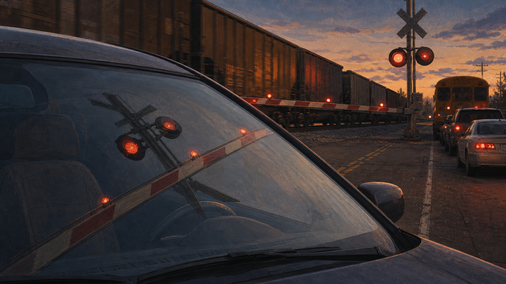
The Bell at the Crossing
A railroad crossing looks like a simple warning. Up close it is a public database, a private right-of-way, a federal signal code, a state priority list, and a local road where risk has to stop in time.
The Sign With a Number
The railroad crossing begins with an object so familiar that most drivers stop seeing it.
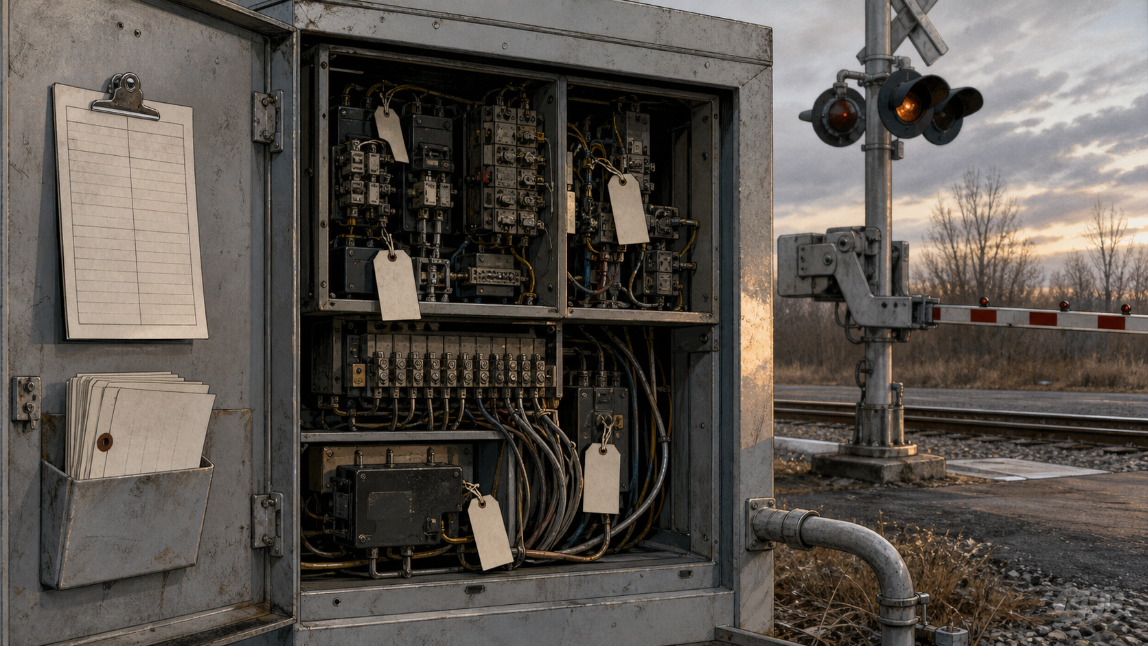
There is the white crossbuck, two boards arranged into an X. There may be red lights, a silver bell, a gate arm, pavement markings, stop lines, advance-warning signs, and a small blue emergency notification sign. The blue sign is the least poetic object in the scene. It is also the one that admits what the rest of the crossing tries to hide. An assigned record sits behind the pavement.
Federal grade-crossing safety rules require emergency notification signs to display a telephone number, an explanation of the sign’s purpose, and the U.S. DOT National Crossing Inventory number assigned to that crossing. 49 CFR Part 234 places that duty inside the federal signal-safety framework. The same rule requires the sign to be retroreflective, legible, and placed so a road user can see it. A driver with a stalled car, a broken gate, or a blocked view is supposed to have a number to call and an ID to give.
That is a small bureaucratic miracle. The roadside sign turns panic into coordinates. It tells the public that the crossing has a responsible railroad, a dispatching path, a recordkeeping trail, and a name inside a federal inventory.
The bell and lights get attention because they move. The inventory number tells the deeper story. The country has so many points where public roads cross railroad tracks that it cannot rely on memory, courtesy, or local rumor. It needs a register.
A live query of the Federal Railroad Administration’s public Crossing Inventory
on June 4, 2026 returned 203,382 published, open, at-grade crossing records. Of those, 199,991 were listed with the crossing purpose Highway, 2,724 with Pathway,Ped., and 667 with Station,Ped. The query functions as a scale check. A country with more than two hundred thousand open at-grade crossing records has turned the simple act of crossing tracks into a national recordkeeping problem.
That is the first lesson of the crossbuck. The X at the road may look like a symbol. In practice it is an address in a public safety system.
Where the Road Meets the Rail
A grade crossing is a dispute made physical.
The road says ordinary people, school buses, ambulances, delivery trucks, farm equipment, tourists, and commuters need a continuous path. The railroad says freight and passengers move best when steel wheels keep rolling on steel rails with as little interruption as possible. Both claims are legitimate. Both can become dangerous when treated as absolute.
The crossing is where those claims occupy the same pavement.
That shared pavement is unlike most traffic risk. At an intersection, cars negotiate with cars. At a crossing, a driver meets a train that cannot stop like a car, cannot swerve like a car, and cannot bargain once it is near. The warning system has to act before the driver can misjudge distance, before a vehicle can stall, before a second train hides behind the first, before impatience becomes a decision.
The Federal Railroad Administration’s public highway-rail grade crossing accident data makes the problem less abstract. A live query of that dataset for 2025 returned 2,272 crossing incidents, 314 deaths, and 755 injuries. Those numbers should be read with care. Each entry sits behind a local place, a vehicle, a train, a weather condition, a warning device, and a report form. The aggregate is useful because it resists the comforting idea that crossings are mainly relics of an older America.
Another query of the same 2025 accident data, grouped by the first recorded warning-device field, returned 1,155 incidents with Gates, 406 with Stop signs, and 383 with Crossbucks. That field does not explain causation. It does something more modest. It shows that visible protection does not remove the shared problem. Gates can be present. Stop signs can be present. Crossbucks can be present. A train and a road user can meet anyway.
The modern economy keeps asking rail to carry heavy things across long distances. Local life keeps asking roads to be open. The crossing asks both systems to share a narrow point and do so safely, day after day.
A Warning Is a System
The visible warning is only the front of the machine.
The national vocabulary is older than the modern crossing signal. FHWA’s history of the MUTCD traces early 1920s uniform-sign work to a simple material fact: drivers needed to recognize danger by shape when letters were hard to see at night. Round signs warned of approaching railroad crossings because those crossings represented the highest danger to drivers. In 1935, the first MUTCD put signs, markings, signals, and islands into one national manual. In 1978, the MUTCD added dedicated parts for highway-rail grade crossings and bicycle facilities. The crossbuck inherited that shift.
The current Manual on Uniform Traffic Control Devices , maintained by the Federal Highway Administration, carries that inheritance forward.
The Part 8 PDF
identifies the Grade Crossing sign, commonly called the Crossbuck sign, as a retroreflective white sign with the words RAILROAD CROSSING in black lettering. As a minimum, it says one crossbuck shall be used on each highway approach to every highway-rail grade crossing. At passive crossings, the crossbuck assembly pairs that familiar X with a yield or stop sign where the standard calls for it. Part 8 also names the joint-use problem directly: for design, installation, operation, and maintenance of traffic-control devices at grade crossings, the crossing sits on a right-of-way available for joint use by highway traffic and railroad or light-rail traffic. The road and the railroad pass near each other, then share a piece of ground where two legal and physical systems meet.
The railroad side has its own code. 49 CFR Part 234 governs grade crossing signal system safety. It covers reporting, inspection, testing, maintenance, response to malfunctions, emergency notification systems, and crossing-inventory reporting. A gate that descends late, a light that fails, a sign hidden by vegetation, a phone number that reaches the wrong place, or a record that never gets updated can turn a routine crossing into a trap.
The bell carries that hidden machinery into the road: detection circuits, signal cabinets, dispatch responsibility, maintenance records, and federal rules. Its sound interrupts the driver’s sense that the road belongs to him. The gate makes the interruption physical.
At the pavement, all of that work becomes one human requirement: stop before steel arrives.
The warning at the road depends on records, circuits, maintenance, and a dispatch path.
The Database Under the Bell
The inventory is the hidden civic document in the scene.
FRA’s public Crossing Inventory carries fields that sound mundane until a crossing fails: crossing ID, railroad, state, county, street, latitude, longitude, crossing purpose, number of tracks, train counts, school-bus route status, pavement markings, signs, bells, flashing lights, gates, traffic signals, and whether the crossing is closed. A crossing becomes a row of facts because money, maintenance, and blame all need a record.
Part 234 gives that record legal force. It requires reporting and periodic updates to the U.S. DOT National Highway-Rail Crossing Inventory. It also contains the emergency notification sign rule. Local memory alone cannot carry the crossing.
The emergency sign also has a date on it, even when the sign itself does not. FRA’s 2012 final rule on Emergency Notification Systems required railroads to establish systems at highway-rail grade crossings to receive telephonic reports of unsafe conditions and route those reports to the right railroad contact. A road user should not have to know which railroad owns the track or which dispatcher controls the line while a vehicle is stuck on the crossing. The blue sign supplies a phone number and a crossing identity.
State planning now carries the same premise.
Section 234.11 requires state highway-rail grade crossing action plans. Those plans must identify crossings that have experienced recent incidents, identify specific strategies for improving safety at crossings, and, where relevant, address closures, grade separations, and other treatments. The database gives public agencies a way to notice, rank, fund, and revisit danger.
Without that record, the worst crossings can become local folklore. Everybody nearby knows the sightline is bad, the queue backs up, the road floods, the lights are hard to see at sunset, the gate arm gets hit, or the school bus route passes there every morning. Folklore can warn neighbors. It cannot allocate federal funds with discipline.
An inventory can.
Three Ways to Make a List
State action plans show how different public systems translate crossing risk into priorities.
Arizona’s 2022 State Highway-Rail Grade Crossing Action Plan counted 698 active and open public highway-rail crossings: 226 with passive warning devices, 41 with flashing lights, and 431 with lights and gates. Its risk method began with FRA’s New Model for Highway-Rail Crossing Accident Prediction, then adjusted for historical crash data, sight-distance limitations, roadway geometry, number of lanes, and number of main tracks. The result pushes beyond traffic volume. A low-volume crossing with bad sight distance, skewed geometry, multiple tracks, or a difficult road approach can outrank a busier but cleaner crossing.
Texas’s Highway-Rail Grade Crossing Safety Action Plan , a 2011 action plan available through TxDOT’s public file server and FRA’s plan list, starts from repeat collisions. Texas was one of the states named in a 2004 U.S. Department of Transportation Office of Inspector General report for repeated collisions at the same crossing locations. For 2003 through 2007, the plan identified 1,328 public highway-rail crossing collisions in Texas, including 466 at 182 multiple-incident crossing locations.
Texas then looked for patterns: active versus passive warning devices, proximity to adjacent intersections, signal interconnection, vehicle types, trapped vehicles, and metropolitan concentration. It found that 45 percent of statewide collisions were within 75 feet of an adjacent traffic intersection, and it emphasized preemption issues where highway traffic signals sit near crossings.
Missouri’s 2022 Highway-Rail Grade Crossing State Action Plan adds corridor pressure. It reviews incidents from 2016 through 2020, separates passenger-rail corridor incidents, includes blocked-crossing reports, and calls for annual closure and grade-separation priority lists. It also names the local work: stakeholders, corridor solutions, and efforts to reduce the effect of closures.
Together, the plans show three lenses: Arizona refines geometry and sight distance, Texas hunts repeated collision and nearby-intersection patterns, and Missouri treats passenger corridors, blocked crossings, closures, grade separations, and local cooperation as one map problem. No formula sees every way the wrong road can meet the wrong track.
Money at the Stop Line
Safety plans become budget claims.
FHWA describes the Railway-Highway Crossings Program , commonly known as Section 130, as a program that provides funds to eliminate hazards at public railway-highway crossings. It sits inside the Highway Safety Improvement Program. FHWA’s current page says the Infrastructure Investment and Jobs Act continued an annual set-aside of $245 million for fiscal years 2022 through 2026, with funds apportioned to states by formula and projects funded at a 100 percent federal share under the current program description.
The date range is important. On June 4, 2026, the current federal language sits inside the fiscal-year 2022 through 2026 set-aside period. A later expansion or publication after that period would need a fresh funding check. For this draft, the current program page is enough to say that Section 130 remains the named federal crossing-safety program.
That money can buy gates, lights, signs, pavement work, sight-distance improvements, channelization, closure, or grade separation. Each choice moves cost somewhere. A closed crossing can improve safety and irritate a neighborhood. A new gate can reduce collision risk and delay traffic. A separated crossing can remove the conflict and require land, engineering, public money, and years of work.
The Missouri corridor study after the Mendon collision shows the scale of this accounting. MoDOT’s Missouri Railroad Safety Crossing Plan says the department is targeting 48 of 176 passive public crossings along passenger rail corridors for improvements using $50 million in state General Revenue approved in the 2024 budget. The site lists studies, public-meeting materials, and corridor documents for the Southwest Chief, Texas Eagle, and Missouri River Runner routes.
One of those documents, the Southwest Chief/BNSF Marceline Subdivision public report , examined a 190-plus-mile corridor across northern Missouri. It counted 95 public at-grade crossings and 21 passive-only public crossings in the study limits, with more than 60 daily trains, including two passenger trains, and passenger speeds up to 90 mph. Its Tier I recommendations called for seven flashing-light-and-gate upgrades, 11 closures, and three passive enhancements. The report estimated Tier I costs at about $7.6 million and the full corridor plan at about $63.3 million.
The same report is careful about friction: feasibility work, environmental work, stakeholder involvement, local public-agency coordination, agreements, funding, public engagement, closure opposition, railroad coordination, material procurement, and workforce availability.
A crossing can be dangerous enough to close and useful enough that people fight the closure. A route can be safer after consolidation and harder for a farmer, a bus route, a fire truck, or a resident who has used the road for years. Grade separation can be the cleanest safety answer and the hardest public project.
What Closure Does to the Map
Closure is the most elegant word in a plan and the hardest word on a local road.
When a crossing closes, the train-vehicle conflict at that point disappears. The route does not. Texas describes crossing consolidation as an important method for reducing collisions. Missouri’s action plan calls for annual review of closure and grade-separation priority lists. The Southwest Chief corridor report recommends closing 11 passive crossings in its first tier of improvements.
The public does not experience closure as a statistic. It experiences closure as a new route.
A road that once crossed the track now stops, bends, or sends traffic somewhere else. The farm entrance changes. The school bus route changes. The fire department’s mental map changes. A delivery driver loses the shortcut. A resident who has never attended a state rail-safety meeting may be asked to give up the crossing that made sense at the scale of one household or one field.
MoDOT’s phrase regional resiliency/local access carries the local burden. A closure that looks sensible in a statewide safety table has to survive contact with the surrounding road network. If another active crossing is near, the detour is short, emergency response has options, and the land served by the crossing has workable access, closure can be a strong answer. If the closure cuts off practical access or pushes traffic toward another weak point, the solution may only move the argument down the road.
Grade separation has the opposite problem. It preserves movement while eliminating the conflict. A bridge or underpass lets the road and rail line stop negotiating on the same plane. For safety, that is the cleanest idea. For public work, it is expensive, slow, and physical. It needs right-of-way, design, drainage, utility relocation, environmental work, construction staging, and money large enough to change the rest of the project list. Arizona’s plan shows this contrast in one line item: at Bethany Home Road west of 51st Avenue in Glendale, the near-term recommendation was pre-signalization and added lighting; the long-term recommendation was grade separation or closure, with the long-term grade-separation estimate tied to a regional transportation plan at more than $100 million.
That scale changes the politics. A warning-device project may be a rail safety job. A grade separation becomes a road project, a drainage project, a land project, a local access project, and sometimes an economic development project. It can be plainly safer and plainly beyond the funds available for every crossing that deserves attention.
A good state plan has to make those imperfect choices legible: upgrade here, close there, study a bridge later, add signs now, fix pavement markings while the large project waits, and keep the inventory clean enough that future choices start from the record instead of from rumor.
Active Warning Is Not the Finish Line
The presence of gates should calm a driver. It should not calm the public system.
The FRA 2025 accident query grouped by first warning-device field returned more incidents with Gates than with stop signs or crossbucks. That does not prove gates are worse. Busy crossings are more likely to receive active protection, and exposure drives risk. A gate at a high-volume crossing may prevent many crashes that never enter the data. The query cannot count the stopped drivers who waited, cursed, checked their phones, and drove away safely after the train cleared.
The number is useful for a narrower reason. It blocks complacency. Active protection does not end the need for maintenance, signal timing, traffic-signal preemption, queue control, sight-distance management, enforcement, and public attention.
Texas’s action plan understood that point through intersection proximity. It found many crossing collisions near adjacent traffic intersections and highlighted preemption, signal-controller information, and crossings interconnected with nearby highway traffic signals. A gate can descend properly while road traffic is trapped too close to the tracks. A traffic signal can hold cars in a place where the railroad warning system needs room. A driver can obey the highway signal and sit inside the wrong envelope unless the road and rail controls are coordinated.
MUTCD Part 8 speaks to the same problem through engineering studies and Diagnostic Teams. The right device at a crossing depends on the road, the rail line, the geometry, the intersection, the users, and the local context. The crossbuck gives a national sign. The diagnostic process asks whether that sign is enough.
That is a useful distinction. Uniform signs make the crossing readable. Local engineering makes the warning answerable to place.
Porche Prairie Avenue
The national argument becomes concrete at County Road 113 in Chariton County, Missouri.
On June 27, 2022, Amtrak train 4, the Southwest Chief, collided with a dump truck at a highway-railroad grade crossing near Mendon, Missouri. The National Transportation Safety Board’s Railroad Investigation Report RIR-23-09 identifies the crossing as U.S. DOT Crossing Inventory number 005284Y, located where County Road 113, also known as Porche Prairie Avenue, intersected BNSF’s Marceline Subdivision. The train derailed both locomotives and all eight railcars. Three train passengers and the truck driver were killed. One hundred forty-six passengers and Amtrak crewmembers were transported to hospitals. Amtrak and BNSF estimated track and equipment damage at about $4 million.
Those facts are grim enough. The report’s value for this essay comes from its restraint.
Passive protection marked the crossing: crossbucks and stop signs, no flashing lights or gates. Positive train control was enabled and operating. The train horn complied with federal regulations.
On a Class 5 track, maximum allowable speeds were 80 mph for freight trains and 90 mph for passenger trains, and the crossing itself had difficult geometry. County Road 113 crossed the tracks at a 45-degree angle. The NTSB cited American Association of State Highway and Transportation Officials guidance that crossings should be as close as practicable to 90 degrees and no less than 75 degrees. The report says the skew meant an observer in an exemplar truck had to lean forward and look over the left shoulder to see down the track without the B-pillar obstructing the view. The road grade near the crossing was also steep. The NTSB measured a 39-inch drop 30 feet from the nearside rail, a 10.8 percent grade, and noted potholes and humps on the gravel approach.
In the probable-cause statement, the NTSB holds two facts together. The truck driver proceeded into the crossing without stopping despite a stop sign and approaching train, for unknown reasons. The crossing’s design contributed to the collision by reducing drivers’ ability to see approaching trains and making stopping as required by Missouri law difficult for heavy trucks. The driver had a legal duty to stop. The crossing design made that duty harder for the vehicle involved. The train had the right-of-way and could not stop like a road vehicle. The passive crossing had signs. The road approach, angle, grade, and visibility formed a physical context around human behavior.
At the end of the report, NTSB’s own mission statement reinforces the point. The agency says its investigations are fact-finding proceedings, with no formal issues and no adverse parties, and are not conducted to determine rights or liabilities. That posture is valuable here because the crossing deserves a record-first reading. Fault and liability may matter elsewhere. The essay needs the mechanism.
After the collision, Chariton County closed the involved crossing. The NTSB report says the county developed a plan, with the City of Chillicothe and MoDOT, to close several other passive crossings and redesign local roads to direct traffic through active crossings. It also says Chariton County proposed that plan during a public meeting in April 2023 and was seeking state or federal funding.
There is the whole system again: a passive crossing, a public road, a railroad subdivision, a county closure, a city route redesign, a state safety plan, and a public meeting where residents have to live with the new map.
The Blame Problem
Crossing debates often collapse into blame.
One frame treats crashes as driver failure: impatience, distraction, poor judgment, a decision to go around a gate or ignore a sign. Another frame treats the railroad as the obvious heavy party: the train is huge, the company is powerful, the track is private, the warning system is complicated, the consequences are severe. A third frame treats government as the lagging actor because it owns or funds much of the road side of the problem.
Each frame can be true in a particular case. None can govern the whole subject.
A fuller record is more demanding. Drivers make bad choices. Railroads own and maintain critical pieces of warning equipment. States and local road agencies control approaches, pavement markings, road geometry, traffic signals, and project priorities. Federal rules set the inventory and signal framework. Funding programs shape which hazards move first. A safety culture that explains every crash through one actor will miss the machinery that made the risk visible before the crash occurred.
Mendon shows the danger of easy blame. A driver entered the crossing without stopping. The crossing angle limited the view from a heavy truck. The steep gravel approach made stopping and starting harder. The passive warning setup left the driver to see, judge, and act without active lights or gates. The postcollision plan turned the single crossing into a corridor question.
State action plans show the same pattern at a wider scale. Arizona’s plan looks past incident counts to sight distance, roadway geometry, lanes, and tracks. Texas’s plan looks at repeated collisions, adjacent intersections, signal interconnection, metropolitan concentration, and closure. Missouri’s plan treats passive corridors, passenger routes, blocked crossing reports, emergency response delay, and closure politics as one connected problem.
An emergency notification sign gives the scene a chain of responsibility. It presumes that a member of the public may notice danger. It presumes that the railroad needs a direct report. It presumes that the crossing number carries operational meaning. It presumes that unsafe conditions can require remedial action and records. A driver reports the defect by name; the responsible system has to answer the report.
That modesty is worth keeping.
The Future Crossing
The future crossing will probably look ordinary.
It may have a crossbuck, a bell, a blue sign, and a gate arm. It may sit beside a warehouse district where freight rail is busier because e-commerce and manufacturing want heavy things moved cheaply. It may sit in a growing suburb where a quiet road now carries school buses, commuters, cyclists, delivery vans, and emergency vehicles. It may sit on a rural route where a handful of families, farms, and service vehicles depend on a crossing that the statewide risk model sees as low-volume.
The pressures around that ordinary crossing are changing.
Freight rail remains valuable precisely because it moves volume. Passenger rail plans depend on corridors that often run through old towns and rural counties where crossings already exist. Emergency response depends on routes that may be blocked by a stopped train or closed by a safety project. Drivers are more distractible, vehicles are heavier, and local roads are full of use cases the original crossing never imagined.
Automation will help in some places and complicate others. Better signal systems can reduce conflict through preemption, four-quadrant gates, pedestrian gates, vehicle detection, and grade separation. Better data can show where risk is hiding. Better emergency signs can help a public report reach the railroad dispatcher quickly. Better state plans can rank projects without waiting for local tragedy.
None of that removes the human moment. The driver has to stop. The railroad has to maintain. The local road owner has to manage the approach. The state has to choose projects. The federal government has to keep rules, money, and records coherent. Residents have to accept that a safer road network may be less convenient than the one they inherited.
The future crossing should be less romantic and more legible. It should be treated as a small civic machine: sign, signal, record, road, rail, money, and behavior.
The Bell After the Train
The safest crossing is the one where the road and the rail never meet at grade. The country cannot erase every shared crossing at once, and some private, rural, industrial, pathway, or low-volume crossings will always sit in harder engineering territory. A serious public system has to live inside that fact without becoming casual about it.
The bell is a reminder of that compromise.
It sounds before the train because responsibility has to arrive before impact. The red lights flash because the driver’s normal freedom has ended for the moment. The gate lowers because persuasion sometimes needs a bar across the lane. The blue sign waits because the system also needs the public to notice broken things and call them by their assigned name.
There is a kind of civic humility in that scene. The country cannot make a train brake like a sedan. It cannot make every driver patient. It cannot make every local budget generous. It can keep a public inventory. It can require a readable sign. It can maintain circuits and gates. It can fund upgrades. It can close dangerous crossings when the record supports closure. It can refuse to treat a familiar warning as proof that the warning is adequate.
The familiar stop becomes serious when a road, a rail line, and a public record converge.
After the train passes, the gate rises and the road returns to ordinary use. That is what a crossing promises on a good day: interruption, patience, movement again. The sound fades quickly. The record should not.