Who’s Responsible for Building in the Floodplain?
Camp Mystic, Zoning Laws, and the Limits of Federal Power
After 27 people died at Camp Mystic on July 4, a colleague told me
something I haven’t stopped thinking about:
“The federal government is ultimately to blame. They knew the risks. They should’ve stopped people from living or camping in the floodplain.”
It’s an emotionally compelling idea.
The government knew.
They mapped the flood zone.
They issued the warnings.
Camp Mystic remained in harm’s way.
But here’s the hard truth:
The United States just doesn’t work like that.
A Brief Aside, Continue Reading Below ~
This essay looks at what the federal government can (and can’t) do to prevent tragedies like this one. We examine the complicated system of shared responsibility that governs how we live ~ and die ~ in dangerous places.
Disclaimer: The views expressed here are my own and do not represent the official policy or position of the U.S. Army Corps of Engineers, the Department of Defense, or the United States Government.
New here?
Essay #1 : What Happened at Camp Mystic?
Essay #2 : The Water’s Rising
Essay #3 : Flash Flood Alley
Who Controls Where We Build?
The federal government doesn’t control zoning and development law.
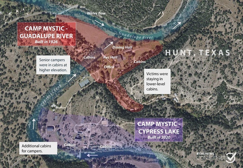
That power belongs to local governments ~ counties, cities, and towns ~ acting under authority granted by the states. It’s been that way since a 1926 Supreme Court case (Village of Euclid v. Ambler Realty) upheld zoning as a legitimate local safety tool.
That means cities and counties get to decide where the homes, summer camps, and trailer parks exist.
Texas follows this model.
In places like Kerr County, where Camp Mystic is located, zoning authority is relatively weak.
Kerr County does participate in FEMA’s National Flood Insurance Program (NFIP), which requires it to regulate construction in flood zones.
Local records treated parts of the Guadalupe River corridor as hazardous.
Essay #3 includes the flood-risk context for Camp Mystic.
That leaves the hard question: why were cabins in the floodway?
Some were built decades ago and were likely grandfathered in.
Others were approved as part of more recent expansions.
Some questions turn on local approvals, map determinations, and appeals, not a simple federal ban.
The federal government’s role is to communicate flood risk ~ think FEMA flood maps and NWS alerts.
The federal government does not have the authority to restrict construction on private and state-owned property.
There are numerous examples of obviously risky places where people choose to live: barrier islands along the Intracoastal Waterway, the cliffs of California, and Tornado Alley.
The federal government can offer or withhold funding and support for key programs to influence localities.
Federal flood insurance is often mandated by lenders for properties located in high-risk flood zones (if the property is financed).
That being said, zoning law is determined by local governments, period.
Local governments approve building plans.
They sign off on emergency preparedness plans.
They inspect the buildings, dot the i’s, and cross the t’s.
All FEMA can do is communicate the risk.
What does FEMA Actually Do?
FEMA doesn’t tell people where to build.
Instead, it sets the rules for federally backed flood insurance.
If a community adopts FEMA’s minimum standards,
then its residents become eligible for coverage.
If they don’t, they’re cut off.
That’s the deal:
Subsidized flood insurance for minimum flood risk reduction measures.
Those minimum standards are often based on outdated assumptions, including the idea of a “100-year flood,” which assumes historical patterns will hold true.
Wait ~ what’s a “100-year flood”?
It doesn’t mean a flood that happens once every 100 years.
It means a flood that has a 1% chance of happening in any given year.
These aren’t expiration dates.
You could have two “100-year” floods back-to-back.
In fact, some Texas towns have.
The problem is that these numbers rely on historical data ~
assuming the past is a good guide to the future.
In Essay #2 , we explored how climate change has made those assumptions less reliable.
On the 4th of July, the water
rose well beyond the 100-year level.
Rain poured in from rivulets and tributaries.
The river swelled beyond its banks.
A wall of water.
Heartbreak.
FEMA didn’t prevent the tragedy.
But it didn’t approve the construction of the camp either.
FEMA provides information about risk and offers a risk informed framework for understanding it.
Local officials and property owners use this information to make decisions about where to build homes, towns, and summer camps.
And the system ~ as designed ~
tolerates risk.
Warning vs. Action
During an Emergency
The federal government doesn’t control how local agencies warn their residents.
The National Weather Service issued its first flash flood warning at 1:14 a.m.
At 4:03 a.m., they upgraded it to a rare Flash Flood Emergency.
At 4:22 a.m., a local firefighter requested that Kerr County send out a CodeRED alert to residents in Hunt, TX.
Local alert delivery lagged behind the weather warning timeline.
Essay #1 lays out the full warning timeline.
Essay #3 breaks down how those delays turned deadly.
By the time Camp Mystic began evacuating around 4:45 a.m., it was already too late for many.
Here’s how it is supposed to work:
- The National Weather Service issues the alerts.
- Local officials get the message to the people on the ground.
- Individuals and organizations (like Camp Mystic) respond to the alerts.
Can the Federal Government Force People to Move?
No.
The federal government can incentivize relocation by funding voluntary buyouts or limiting future disaster aid.
It can’t force local governments to evacuate a town, shut down a summer camp, or relocate a community in advance of a storm.
Why?
Under current law, the feds don’t have zoning authority.
They can’t commandeer states to enforce land use policies (New York v. United States, 1992).
Even after Hurricane Katrina, the government relied on voluntary participation in relocation programs.
Eminent domain
~ where property is taken for public use ~
requires just compensation and is usually used for roads or dam construction,
not immediate flood safety.
In Essay #2 , we showed how flood risk is changing even as those tools remain voluntary.
So Who Is Responsible?
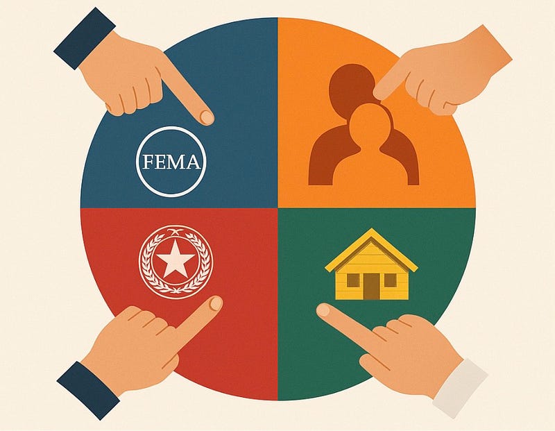
The federal government?
The federal government?
It issued the warnings, mapped the floodplain, funded the insurance program, and administered the map and insurance framework.
The county?
It knew the area was hazardous, controlled local review and alert activation, had tools to require better planning or elevation, and did not move alerts quickly enough.
The camp?
It operated facilities in high-risk areas, had emergency planning gaps now subject to scrutiny, and faced power, communication, and evacuation limits as water rose.
The parents?
They entrusted their children to the camp, assumed it was safe, may not have known it was in a designated floodway, and may not have asked.
The truth is:
No one party is to blame.
It’s all just a part of the picture.
Parents don’t approve site plans or read flood maps…
And they are often told
~ by brochures, word of mouth, or tradition ~
that places like Camp Mystic are safe.
So they sign the forms.
They send their kids.
They trust the system.
And this time, the system let them down.
In Essay #1 , we covered what happened that night.
In Essay #2 , we explained why storms like this are becoming harder to plan from the old record alone.
In Essay #3 , we unpacked how the Hill Country’s terrain turns storms into killers.
What Happens Now?
At the time, FEMA’s future was part of a larger national argument about federal disaster capacity.
Texas was beginning to consider new rules for youth camps and floodplain occupancy.
Kerr County faced pressure to upgrade its emergency communication protocols.
There is no national rule that says “you can’t put kids in a floodway.”
That is unlikely to change.
Catch up on the full Camp Mystic series ~
Essay #1 : What Happened at Camp Mystic?
Essay #2 : The Water’s Rising
Essay #3 : Flash Flood Alley