An Outside In Print book
The Water Cycle: Risk, Infrastructure, and Public Memory
How maps, pipes, insurance, and public decisions shape what communities remember about water risk
A compact book about the maps, pipes, insurance records, reservoirs, and public decisions that shape how communities remember water risk.
- water risk
- infrastructure
- public memory
- floods
- drought
Choose an edition
Direct EPUB checkout is currently available to U.S. customers only.
Outside In Print EPUB
Secure checkout through Square. EPUB delivered by email.
$9.99
Also available
Kindle edition
Purchase and delivery through Amazon.
About the book
The Water Cycle examines how maps, insurance, pipes, reservoirs, drought records, and public decisions translate water risk into ordinary life.
The book follows a single civic problem across floodplains, drinking-water systems, desert infrastructure, and household expectations: engineering and finance can make water easier to use while making dependence easier to forget.
Purchase options, prices, and release status are listed from the bookstore catalog on this page.
Read before you buy
Reading sample
Prologue: A Beach House in Idaho
Water at the Center
Many early settlements grew near reliable water.
Reliable water let many settlements drink, grow food, move goods, remove waste, defend themselves, trade, and generate power. Rivers and harbors often served as working roads, trade routes, and markets. Floodplains renewed soil and supported crops even as they carried danger.
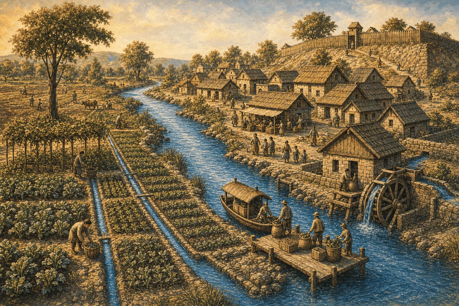
For many settlements, water brought risk and possibility together. Rivers, coasts, springs, harbors, and wet soil shaped survival and growth; they were infrastructure, not scenery.
From a modern distance, people near water can look reckless. Their choices were narrower. Dry safety is not the same as a place that can feed, supply, connect, and sustain a community. Settlement joined the gifts of water to the obligations of living near it.
The obligations were once hard to miss. A community knew when the river rose. It knew which ground stayed wet. It knew which road disappeared after rain and which bank cut away in spring. It knew the smell of the low place, the force of current, the value of a landing, and the danger of forgetting where the water had been. That knowledge did not make people immune to disaster. It did make the terms visible. The public record was stored in habit, story, path, field, landing, and avoidance.
In that older knowledge, the floodplain was active terrain. It carried the river when the channel could not. It received sediment. It stored water. It fed soil. People could fear it and need it at the same time. That double truth is hard for modern institutions to keep alive because institutions prefer separate boxes: water supply over here, flood risk over there, sewer somewhere else, transportation somewhere else again. The water cycle never accepted those boxes.
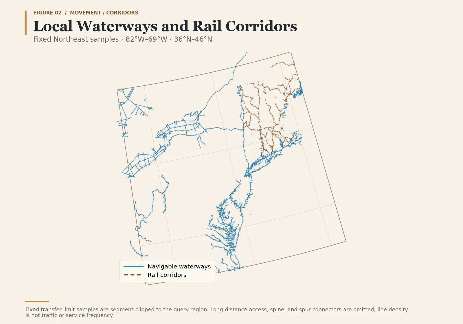
Water was often part of the mental map. Routes followed rivers, coasts, canals, ports, lakes, fords, and ferries where those waterways offered useful connections. Boats moved heavy goods where travel by land was slower or harder. Some cities grew where water helped goods move and people meet. Inland settlements also used river valleys and canals, while railroads and highways later added different routes across distance. In many places, water did not vanish from the economy. Its work in transport, food, industry, and settlement simply became less obvious in many people’s daily experience.
The Mental Map Changes
Then the mental map changed.
Railroads did not make water irrelevant. They added new routes and changed the links people could see. A town linked by steel did not need a navigable channel for every shipment. Later, pipes, pumps, reservoirs, treatment plants, culverts, storm drains, interstates, refrigeration, trucking, air conditioning, and mortgages pushed more of water’s work behind service. The benefit remained immediate while the source, pathway, maintenance, and risk became easier to overlook. Water did the work; the dependency became less visible.
Modern settlement is full of this abstraction. Water arrives under pressure from a pipe. Waste leaves through another pipe. Stormwater vanishes into a curb inlet. Food arrives by truck. Flood risk appears as a map layer. Drought appears as a reservoir graph. A subdivision can sit on ground whose old hydrologic function has been renamed drainage. A household can believe it has chosen a home, when it has also inherited a watershed, a utility, a set of public debts, and a chain of decisions made before closing day.
This is what engineered forgetting looks like when it is working. Daily life becomes smooth enough that the system disappears. The household does not need to know where the water comes from, where the waste goes, which creek takes the overflow, which reservoir is falling, which floodplain stores the storm, which culvert backs up, which warning threshold matters, which insurance rule shaped the mortgage, or which capital plan postponed the repair. The old obligations remain, but they are translated into instruments and accounts. The river is not gone. It has been delegated.
The desert city is the cleanest form of the abstraction. Desert urbanism is not irrational by default. People have always built in hard places by moving, storing, sharing, and governing water. The danger begins when the system works well enough for daily life to feel independent of the water that supports it. A lawn can hide a canal. A subdivision can hide a reservoir. A tap can hide a river hundreds of miles away. A city can become fluent in water engineering and still let the public forget water as a civic fact.
Las Vegas supplies a familiar image of desert abstraction: neon, decorative water, and engineered confidence in a place where water is difficult. The deeper problem is not confined to the desert. Every city with buried pipes, storm drains, insurance forms, and utility bills can hide its dependence behind ordinary service.
Research summarized by NASA Earth Observatory suggests that deforestation may have amplified natural drought in the Maya region. It does not support collapse by one cause. The warning about confidence outrunning changing water conditions is an inference, not the source’s result.1
Every civilization does not repeat the same story. The useful warning is narrower: public water knowledge can fail even in sophisticated societies. A community can become technically capable and politically confident at the same time that it becomes less honest about dependency. It can mistake an engineered system for an escape from the water cycle. It can treat a good run of years as proof of permanent safety. It can forget that water records decisions slowly and then presents the bill quickly.
A Beach House in Idaho
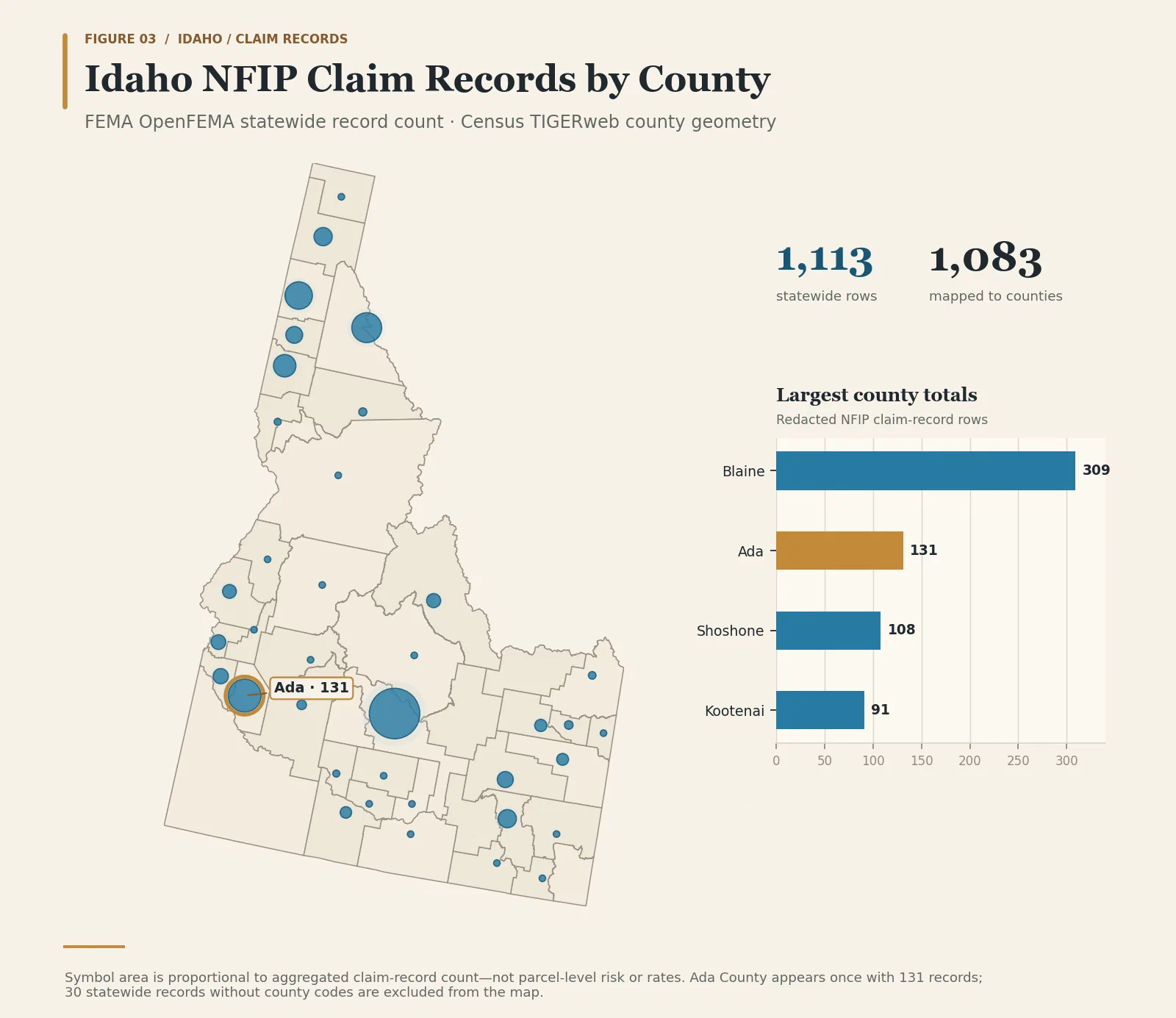
The phrase “a beach house in Idaho” works because it sounds impossible. It depends on false distance: the coast is elsewhere, the water problem belongs somewhere else, the bad deal is someone else’s. Idaho has no secret coastline. It still sits inside the water cycle.
That distance is the illusion. Civilization loves water because civilization needs water. That love has terms, and forgetting those terms is the problem.
The River Enters the Paperwork
Before federal maps, insurance requirements, flood zones, mortgages, zoning, alerts, utilities, reservoir operating plans, outfall inventories, and public agencies translated water into forms, humans went to water because water made life larger. Modern institutions inherit those old terms. They preserve pieces of it through maps, policies, premiums, local decisions, and emergency systems, while the full obligation can still fade from view.
That translation does not usually feel dramatic while it is happening. It can feel like ordinary competence. A family looks at a listing. A lender asks for documents. A closing packet includes requirements that feel technical and final. A county map appears on a screen. A disclosure form uses official language. A premium becomes one more number in the monthly cost of a life. A drainage note, a setback, an elevation certificate, an insurance requirement, or the absence of a requirement all speak in the calm voice of administration. None of those instruments feels like a river. Together they are how the river enters the paperwork.
The household does not usually meet the watershed as a watershed. It meets square footage, school zone, commute, shade, a yard, a porch, a price, a loan, a monthly payment, a closing date, and a sense that a decision has become possible. The old reasons for going to water are still there, changed but recognizable. People want access, beauty, work, recreation, soil, view, identity, family continuity, and a place that feels like arrival. The public system either brings the hidden terms into that decision or lets the smoothness of the transaction stand in for warning.
The same river valley that made settlement possible can become a subdivision, a camp, a road, a wastewater plant, a recreation corridor, a tax base, a mortgage market, a set of emergency routes, and a public expectation that rescue and rebuilding will be available if the old terms turn hard. Modernity multiplies the obligations. More people can live in more places because institutions have made the terms legible enough to finance, regulate, insure, and service. The danger begins when legibility is mistaken for completeness.
An official map can be the most honest document in the room and still be too small for the decision people think it settles. It can say something true about a modeled flood source, a regulatory boundary, or an insurance requirement. It cannot say everything about local drainage, blocked culverts, saturated soil, upstream development, future rainfall, road access, household vulnerability, or the speed with which water can turn a familiar place into a trap. The map is not weak because it is partial. It becomes dangerous when its partiality disappears from public understanding.
Water’s record becomes administrative at the point where old civilizational dependence enters the modern stack. A floodplain becomes a mapped category. A mapped category becomes a policy question. A policy question becomes a premium, a lender requirement, a local ordinance, a permit condition, a disclosure, an emergency plan, or a line a buyer never learns how to read. The water has not moved. The record has changed forms.
Water made settlement possible. It carried risks and gifts together, and human beings chose among dependencies. That old obligation deserves recognition before modern costs are judged through the public records we inherit.
Gratitude has to come before accusation. River valleys, coasts, harbors, and floodplains carried value before modern categories named their risks. They fed settlements, moved goods, received people, held soil, opened markets, and created wealth. Without that value, accusation turns into scolding. The harder and more useful truth is that the same qualities that made water places valuable also made them demanding.
The early city knew water as presence. Modern life often knows water as service. That shift changes the moral atmosphere. Presence must be negotiated. Service is expected. Presence has moods, seasons, smells, edges, and warnings. Service has pressure, billing, reliability standards, and customer complaints. Both matter, but they teach different public habits. A city that experiences water only as service can start to believe that the system has converted a relationship into a product. Then the flood, drought, overflow, or outage arrives and reveals the relationship underneath.
The railroad, the pipe, and the pump did not make Americans ignorant of water. They made forgetting easier. A canal remembers a geography of trade. A sewer remembers a decision about waste. A reservoir remembers scarcity made governable. A levee remembers a chosen boundary against water’s force. Trouble begins when the system becomes so successful that the public mistakes it for independence.
A beach house in Idaho sounds impossible because it treats water risk as coastal and distant. The joke weakens once inland water enters the frame: snowmelt, river flood, flash flood, reservoir management, irrigation dependency, drought, groundwater stress, and insurance claims. Water risk is not one place. It moves through a cycle.
Settlements often form near water; institutions arrive later. They inherit the old bargain and make it legible through tools: maps, premiums, policies, rules, permits, gauges, alerts, and claims. Some tools are indispensable. Some are blunt. Some are misunderstood. Some preserve warning, and some make forgetting easier. The old love of water becomes modern administration.
The old obligation comes before the paperwork. The settlement at the river’s edge answers hunger, distance, waste, power, and trade. Only after that answer is honored can modern public life be judged for how badly it remembers the costs.
The issue is not the human desire to live near water. It is the modern fantasy that people can keep the gifts while outsourcing the terms.
Water has memory only in a material sense. It follows pathways: geology, rainfall, snowmelt, drainage, heat, storage, and gravity. Places record that behavior, and public records decide whether people will remember it before surprise arrives.
Water is good and dangerous at the same time. The river that feeds can flood. The harbor that enriches can expose. The aquifer that sustains can decline. The pipe that protects can overflow. The reservoir that secures a city can reveal absence. The same thing that made settlement possible keeps asking for public honesty.
Maya drought caution. NASA Earth Observatory summarizes research indicating that deforestation may have amplified naturally occurring drought. The source does not support a single-cause explanation of Maya collapse. NASA Earth Observatory, Mayan Deforestation and Drought, February 1, 2012 . Accessed 2026-05-29. Use as narrow historical caution, not as a direct analogy to modern U.S. settlement. ↩︎
Direct format
- EPUB